


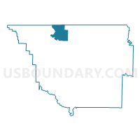
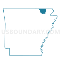
Baker Voting District, Randolph County, Arkansas
About
Outline

Summary
| Unique Area Identifier | 527936 |
| Name | Baker Voting District |
| County | Randolph County |
| State | Arkansas |
| Area (square miles) | 16.20 |
| Land Area (square miles) | 16.16 |
| Water Area (square miles) | 0.04 |
| % of Land Area | 99.74 |
| % of Water Area | 0.26 |
| Latitude of the Internal Point | 36.46230520 |
| Longtitude of the Internal Point | -91.13431280 |
Maps

Graphs
Select a template below for downloading or customizing gragh for Baker Voting District, Randolph County, Arkansas


Neighbors
Neighoring Voting District (by Name) Neighboring Voting District on the Map
- Cedar Bluff Voting District, Oregon County, MO
- Dalton Voting District, Randolph County, AR
- Gatewood & Union Voting District, Ripley County, MO
- Jackson Voting District, Randolph County, AR
- Warm Springs Voting District, Randolph County, AR
Top 10 Neighboring County Subdivision (by Population) Neighboring County Subdivision on the Map
- Gatewood township, Ripley County, MO (394)
- Myrtle township, Oregon County, MO (388)
- Warm Springs township, Randolph County, AR (332)
- Dalton township, Randolph County, AR (254)
- Jackson township, Randolph County, AR (241)
- Cedar Bluff township, Oregon County, MO (91)
- Baker township, Randolph County, AR (55)
Top 10 Neighboring Elementary School District (by Population) Neighboring Elementary School District on the Map
Top 10 Neighboring Unified School District (by Population) Neighboring Unified School District on the Map
- Twin Rivers School District, AR (3,374)
- Maynard School District, AR (3,084)
- Couch R-I School District, MO (1,228)
Top 10 Neighboring State Legislative District Lower Chamber (by Population) Neighboring State Legislative District Lower Chamber on the Map
Top 10 Neighboring State Legislative District Upper Chamber (by Population) Neighboring State Legislative District Upper Chamber on the Map
- State Senate District 33, MO (184,118)
- State Senate District 25, MO (169,588)
- State Senate District 10, AR (80,214)
Top 10 Neighboring 111th Congressional District (by Population) Neighboring 111th Congressional District on the Map
Top 10 Neighboring Census Tract (by Population) Neighboring Census Tract on the Map
- Census Tract 9602, Randolph County, AR (6,230)
- Census Tract 8702, Ripley County, MO (2,958)
- Census Tract 4803, Oregon County, MO (2,642)